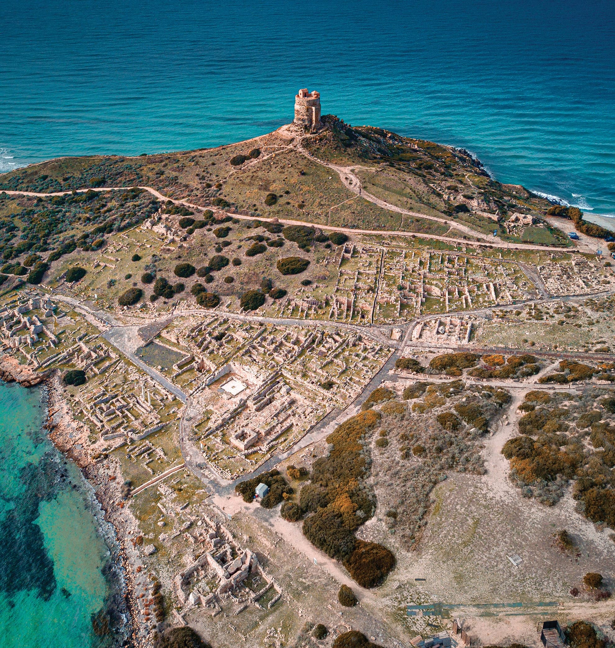
If you lean over the edge of the Spanish tower of San Giovanni di Sinis on a day when the Mistral wind is howling, you immediately understand why the history of Sardinia runs through here. To the west, the "living sea" crashes violently against the basalt cliffs, throwing up walls of white foam. To the east, the "dead sea" of the Gulf of Oristano is a flat, motionless expanse of blue, protected by this narrow tongue of land. Caught between this geographical dichotomy lie the ruins of Tharros.
But what you see strolling today among the wave-lapped remains is only a fraction of the truth. Another slice of the city lies hidden beneath the seabed, swallowed by a slow, relentless bradyseism that has redrawn the coastline over the centuries. In a single square meter of this promontory, archaeologists have read a summary of three thousand years of Mediterranean history. First came an indigenous Nuragic settlement, then a Phoenician port, a Carthaginian military stronghold, Roman engineering luxury, and finally, medieval abandonment. Tharros didn't die suddenly under a volcano or in a single battle: it was slowly dismantled, stone by stone, to build a different world entirely.
The Sinis Peninsula and the Nuragic Roots
The choice of location was no accident. The Sinis peninsula (in central-western Sardinia) stretches into the Sea of Sardinia like a hooked finger, ending in the rugged cliff of Cape San Marco. This strip of land offered a natural harbor, sheltered from the dominant northwesterly winds. It was an essential stopover on the ancient coastal trade routes connecting North Africa, the Balearic Islands, and the Iberian Peninsula.
But when the first Levantine sailors stepped onto the Sinis sand, around the 8th century BC, the promontory was not empty. On the hill of Su Muru Mannu, the highest and most strategic point of the isthmus, an important Nuragic village already stood. The people of Bronze Age Sardinia had erected circular stone huts, visually dominating the entire gulf. Archaeological excavations conducted in the 1950s by Gennaro Pesce, and later by Enrico Acquaro, revealed the unmistakable remains of this indigenous settlement.
The transition to a new era wasn't immediate, nor, it seems, violently imposed from the start. Artifacts show a phase of coexistence or at least intense trade: among the local Nuragic impasto pottery, archaeologists found fragments of cups produced in Euboea and Corinth, brought here in the holds of Phoenician ships. However, when Carthage—the great North African power—took definitive control of the island around the end of the 6th century BC, the sharing stopped. The Carthaginians (Punics) leveled the Nuragic village and reused its basalt blocks to lay the foundations for their buildings and massive defensive walls, erasing the indigenous skyline to make room for a new maritime capital.
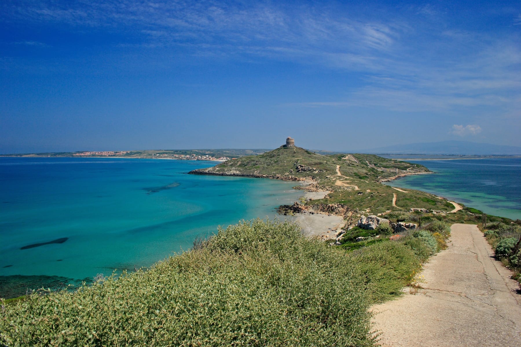 The isthmus of Tharros: the rough 'living sea' on the left, the calm waters of the Gulf on the right.
Lords of the Sea: Phoenician Arrival and the Punic Fortress
The early Phoenician Tharros (8th-6th century BC) was an emporium, a trading post where Sardinian metal was bartered for exotic goods. It was not yet the monumental city whose remains we see today. The Phoenicians lived in close contact with the water, building light port structures of which only faint submerged traces and rich burial goods remain. In the inhumation and cremation necropolises found north of the town, archaeologists have unearthed Egyptianizing steatite scarabs, glass paste jewelry, and exquisitely crafted gold ornaments, proving this was an incredibly prosperous mercantile society.
Everything changed with the arrival of the Carthaginians. Following the military expedition of General Malchus (around 540 BC), Sardinia became the breadbasket of Carthage, and Tharros took on the role of an armed stronghold. To protect the city from landward attacks coming from the Sardinian interior, the Punics executed a cyclopean feat of military engineering: the defensive moat of Su Muru Mannu.
Carved directly into the solid basalt rock, the moat reached a width of 15 meters (nearly 50 feet) and a depth exceeding 10 meters in some spots. Immediately behind it stood a dry-stone wall up to five meters thick, built by interlocking enormous polygonal blocks—some clearly stolen from dismantled Nuragic towers. The Punic city became impenetrable. Inside the walls, the town was structured into regular blocks featuring courtyard houses and distinctive "bathtub-shaped" cisterns, thickly plastered with waterproof cocciopesto (crushed pottery and lime) to catch every single drop of rain in a landscape famously devoid of fresh springs.
The Deciphered Mystery of the Tophet
Few areas of Tharros have generated as much academic debate as the Tophet, located in the northwestern part of the site. Systematically excavated by Sabatino Moscati's team, this is an open-air sanctuary typical of Phoenician-Punic settlements across the central Mediterranean.
Walking through the area today, you'll spot hundreds of sandstone stelae (most are faithful replicas; the originals are safe in museums) planted in the ground, decorated with crescent moons and the symbol of Tanit, a female deity of fertility. Beneath these stelae, for centuries, thousands of clay urns were buried. Inside were the ashes of newborns or even fetuses, often accompanied by the cremated remains of kids and lambs.
For decades, largely due to classical Greek and Roman literature (which was deeply hostile toward Carthage), it was believed that the Tophet was the macabre theater of infant human sacrifices, offered to appease the wrath of the god Baal Hammon. Today, physical anthropology and osteology have overturned this narrative. Analysis of the tiny teeth and unburned bones has proven that the vast majority of these infants died of natural causes before or during childbirth. The Tophet was not a slaughterhouse; it was a specialized cemetery, a sacred area dedicated to the most fragile members of the community who, not having passed childhood initiation rites, could not be buried in the adult necropolis. It was a place of mourning and a plea for future fertility, entrusted to the goddess Tanit.
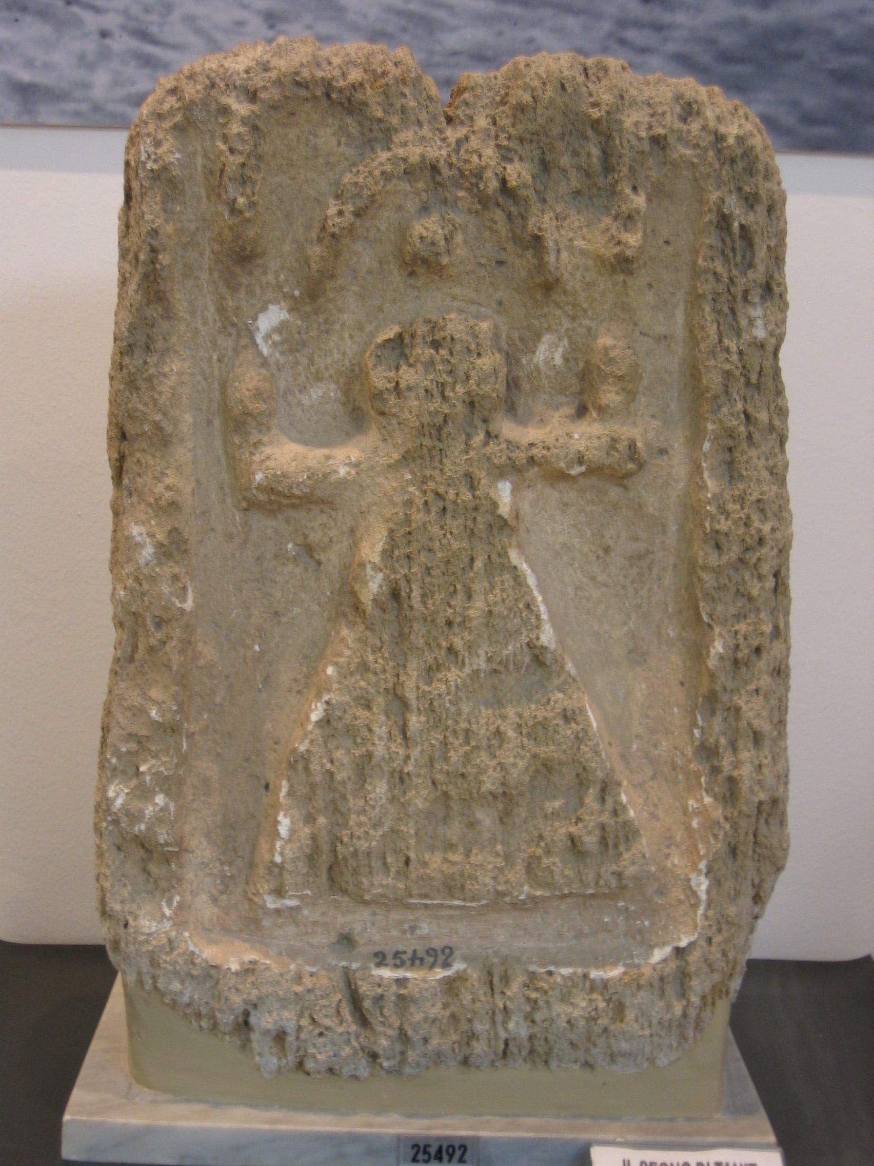 Replicas of Punic stelae in their original setting. The sands of the Tophet held over 3,000 cinerary urns.
Rome’s Imprint: Basalt, Baths, and Aqueducts
In 238 BC, taking advantage of Carthage's weakness after the First Punic War, Rome seized Sardinia. Tharros changed hands without obvious signs of a devastating siege, but it underwent a radical urban renewal that gave it the monumental appearance we admire today on the surface.
The Romans did what they did best: they paved and channeled. The entire road network was capped with enormous slabs of black volcanic basalt rock, meticulously cut and fitted. Even today, walking down the Cardo Maximus, you can see the deep longitudinal ruts carved by the relentless passage of cart wheels over the centuries. Beneath these streets, Roman engineers built a complex cloaca (sewer) system, covered by perforated stone slabs for rainwater runoff, which discharged directly into the sea, flushing the city clean.
Tharros's chronic problem had always been the water supply. Rome solved the issue by building an aqueduct nearly three kilometers long, channeling water from springs to the north down to the Castellum Aquae, a massive distribution reservoir located in the heart of the city.
This abundance of water allowed the construction of no fewer than three thermal bath complexes. The most impressive is the "Convento Vecchio" (Old Convent, named after a modern local legend). Here, the sequence of Roman bathing is still perfectly readable: the changing rooms (apodyterium), the cold pools (frigidarium), and the heated rooms (tepidarium and caldarium). The floors of the heated rooms were suspended on small brick pillars (suspensurae) to allow boiling air, generated by wood furnaces, to circulate directly beneath the citizens' feet.
And what about the two famous Doric columns that tower in every postcard of Tharros? We must clarify one thing: the Romans did not erect them in that precise spot. They are genuine ancient shafts that were hoisted upright in the 1950s by modern excavators, partly for aesthetic reasons and partly to give some verticality back to a site that felt entirely flattened to the ground. They are real artifacts, but their current position is a monumental "historical fake."
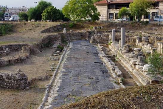 The heavy basalt slabs of the Roman road system. In the center, the drainage channel leading to the sewers.
The Water Rises, the City Dies: The Sunken Port
Let's look back at the sea. Why is half of Tharros underwater? The answer lies in a geological phenomenon known as positive bradyseism—a slow sinking of the Earth's crust—combined with the general rise in Mediterranean sea levels (eustatism) over the last two thousand years.
The ancient Punic and Roman shoreline lay dozens of meters further out than today's water's edge. On days when the sea is perfectly calm and clear, underwater archaeologists have identified squared blocks, fragments of piers, and port structures resting at nearly two meters of depth. The port of Tharros, once bustling with cargo ships laden with grain, wine amphorae, and garum (fish sauce), is today the habitat of sea bream and seabass. Scholars believe that part of the ancient port district was literally submerged and then battered to pieces by the mechanical action of winter Mistral waves.
The end of Tharros, however, did not come from the water, but from the east. After the fall of the Roman Empire and a brief Byzantine interlude (which left behind a beautiful early Christian baptistery near the ruins), the Mediterranean became a dangerous sea. Starting in the 8th century AD, Saracen pirate raids from North Africa became increasingly ruthless. The city, though fortified, was simply too exposed on the coast.
In 1070 AD, a drastic decision was made. Bishop Zaccaria and the Judge of Arborea (the local ruler) decided to move the diocese and the population inland, founding Aristianis, modern-day Oristano. From that moment, Tharros ceased to be a city and became an open-air stone quarry. Columns, capitals, basalt paving stones, and Punic blocks were loaded onto carts and used to build the churches, walls, and palaces of Oristano. Archaeologists call it "spolia": the DNA of Tharros still lives on in the foundations of the modern city.
5 Details to Hunt For Among the Ruins
Visiting a site of this scale can be disorienting. Here are five details not to miss that give concrete reality to millennia of history:
- The Cart Ruts: On the Cardo, near the baths, look for the deep grooves in the hard basalt. They aren't flaws in the stone: it is the wear left by centuries of heavy cargo carts.
- Lead Pipes: In the ruins of the Castellum Aquae and near the Convento Vecchio baths, you can still spot fragments of the lead pipes (fistulae) used by the Romans to divert water into the pools.
- The "Bathtub" Cisterns: Scattered throughout the site are deep, elongated oval pits. These are Punic domestic cisterns. If you peer in (carefully), you'll see that the red waterproof plaster (cocciopesto) is still intact after 2,500 years.
- The Baptismal Font: Before entering the actual archaeological site, there is an early medieval church. Nearby sits a large hexagonal baptismal font, carved directly into a single, immense block of rock. It marks the transition between Late Antiquity and the Christian era.
- The Brickwork Contrast: Look closely at the Roman Baths. You will see large black basalt blocks mixed with bands of red baked bricks. This hybrid style (opus mixtum) is the unmistakable signature of Roman builders adapting to Sardinia's materials.
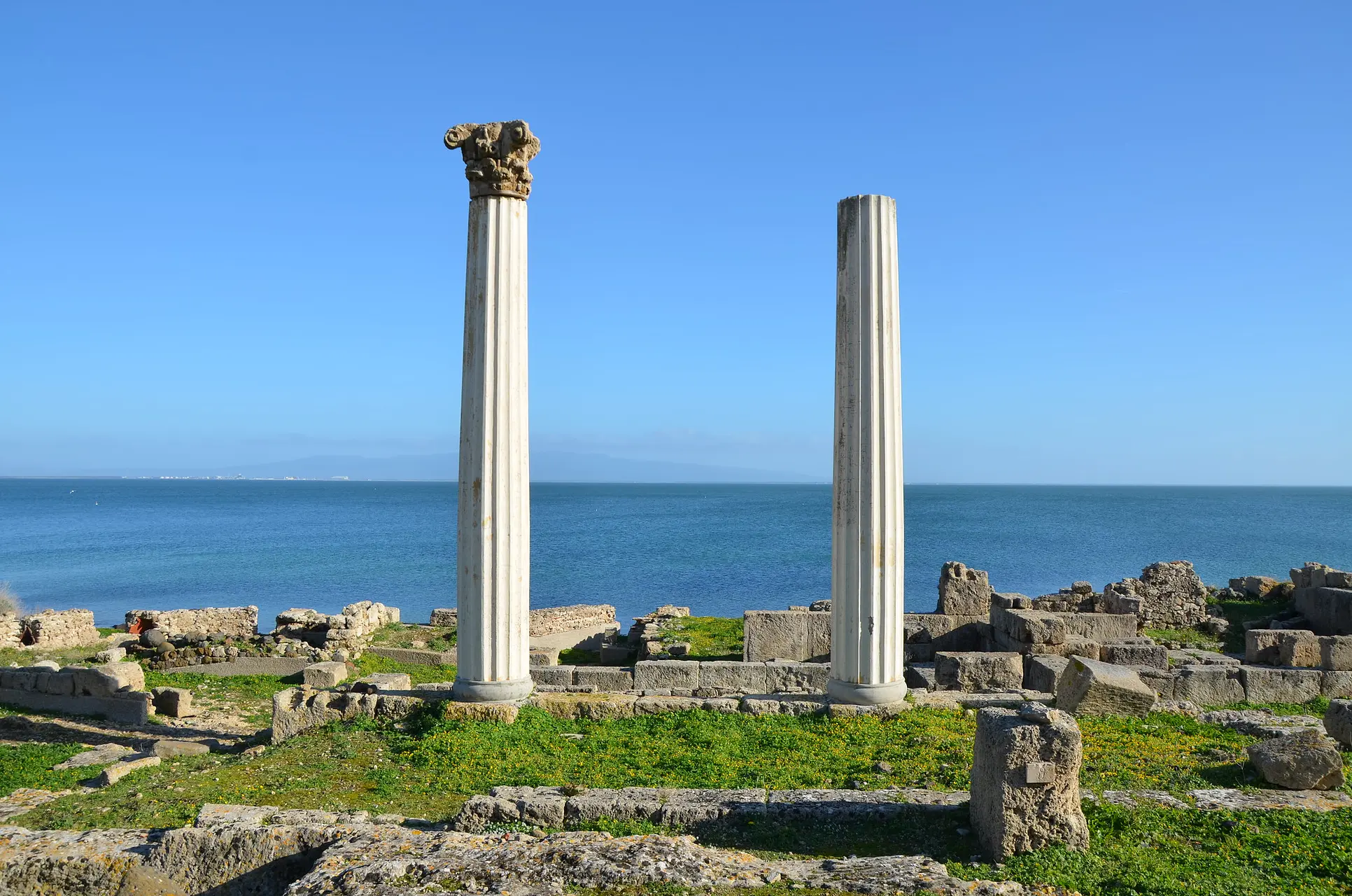 The two iconic columns standing tall on the promontory. They were repositioned in the 1950s by archaeologists.
Visiting Tharros Today
The archaeological area of Tharros is located in the municipality of Cabras. Access to the site requires a ticket, which often includes a visit to the Giovanni Marongiu Civic Museum in the town of Cabras itself. This museum is a mandatory stop: it is there, not among the coastal ruins, that the material treasures are kept. From the Tophet urns to refined Punic gold jewelry, up to the world-famous Giants of Mont'e Prama (found at a nearby site).
There is virtually no shade in the excavation area: in summer, temperatures radiating off the black basalt easily exceed 40°C (104°F). Early morning, with the crisp air and the sun rising over the gulf illuminating the yellow sandstone, is the only time you can truly hear the voice of this immortal city in silence.